
Odile downgraded to Tropical Storm
LOS CABOS, MEXICO – The Hurricane Odile was downgraded to tropical storm on monday evening. The wheater front pushed up Mexico’s Baja California Peninsula early Tuesday, dumping heavy rains that could bring dangerous flash floods and mudslides but also a potential boon to the drought-stricken region.
AP report that Mexico’s government said late Monday night that army and commercial planes would be sent to La Paz and Los Cabos airports to ferry out some of the tens of thousands of tourists stranded in temporary shelters in hotels. Los Cabos international airport was damaged by the storm and it will be closed until sept. 22.
Charly Park, 52, flew in from Los Angeles on Sunday but instead of checking into his hotel room, he and his wife spent the night at a cramped, hot shelter. “It’s a horrible experience, no air conditioning, no fans … the power lines all fell down,” Park said.
Emergency officials in Baja California reported that 135 people have been treated for minor injuries from flying glass or falling objects, but there were no serious injuries or deaths so far. About 30,000 tourists were in temporary shelters.
Before moving north late Monday, Odile made landfall near Cabo San Lucas as a powerful Category 3 hurricane before rapidly weakening. It toppled trees and road signs along the main highway, which at one point was flooded by rushing waters. Windows were blown out of high-end hotel rooms and resort facades crumbled to the ground.
Most of the area’s power poles were blown over, leaving 239,000 people in the state of Baja California Sur without electricity, said Luis Felipe Puente, national coordinator for Civil Protection.
“In the seven years I’ve been here, I’ve never seen anything hit like this,” said Alejandro Tealdi, a 32-year-old resident of Cabo San Lucas whose home was damaged.
Many homes and businesses were reduced to shells with only the core structure intact. The walls of an OfficeMax collapsed into the parking lot. A convenience store was torn apart with the contents of its shelves dumped to the ground, and some locals helped themselves to food, water and other goods.
In Colonia Unidad Real, a neighborhood that sprang up years ago in a former creek bed, hundreds of homes were damaged or destroyed with debris scattered everywhere.

After spending a harrowing night with her in-laws, Graciela Castillo Monroy, 44, and her family returned to find the roof of their home gone and all but two of its cinderblock walls collapsed. They piled what belongings could be salvaged atop a soggy mattress and began picking up the pieces.
“Well, time to start over again,” Monroy said.
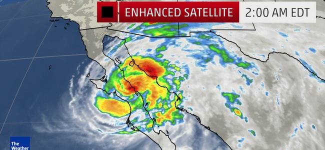
Odile continued to lash the state of Baja California Sur with strong winds and heavy rains as it marched northward, but it weakened to a tropical storm late Monday night.
The U.S. National Hurricane Center said the storm had maximum sustained winds near 65 mph (100 kph). It was centered about 60 miles (95 kilometers) northwest of Loreto and moving to the north-northwest at 13 mph (20 kph).
Odile was expected to drop 6 to 12 inches of rain with isolated accumulations of 18 inches, threatening to unleash dangerous flash floods and landslides.
Meanwhile in the central Atlantic, Hurricane Edouard strengthened to a Category 2 storm Monday night with maximum sustained winds near 110 mph (175 kph), although it was forecast to remain far out at sea and pose no threat to land.
The U.S. hurricane center said Edouard’s center was 520 miles (840 kilometers) east-southeast of Bermuda and was moving north-northwest at 13 mph (20 kph).
NOAA BULLETTIN: DISCUSSION AND 48-HOUR OUTLOOK
AT 1100 PM PDT...0600 UTC...THE CENTER OF TROPICAL STORM ODILE WAS LOCATED NEAR LATITUDE 27.0 NORTH...LONGITUDE 112.5 WEST. ODILE IS MOVING TOWARD THE NORTH-NORTHWEST NEAR 12 MPH...19 KM/H...AND THIS GENERAL MOTION WITH A DECREASE IN FORWARD SPEED IS EXPECTED THROUGH TUESDAY MORNING.

A TURN TOWARD THE NORTH AND NORTH-NORTHEAST WITH AN ADDITIONAL DECREASE IN FORWARD SPEED IS EXPECTED LATE TUESDAY AND TUESDAY NIGHT.

ON THE FORECAST TRACK...THE CENTER OF ODILE WILL CONTINUE TO MOVE OVER THE BAJA CALIFORNIA PENINSULA THROUGH
TUESDAY...AND MOVE OVER THE NORTHERN GULF OF CALIFORNIA ON WEDNESDAY.

MAXIMUM SUSTAINED WINDS ARE NEAR 65 MPH...100 KM/H...WITH HIGHER GUSTS.
WEAKENING IS FORECAST DURING THE NEXT 48 HOURS...AND ODILE IS LIKELY TO BECOME A TROPICAL DEPRESSION BY EARLY WEDNESDAY.

TROPICAL STORM FORCE WINDS EXTEND OUTWARD UP TO 160 MILES...260 KM FROM THE CENTER.  A WIND GUST TO 55 MPH...89 KM/H...WAS RECENTLY REPORTED NEAR SANTA ROSALIA MEXICO.

THE ESTIMATED MINIMUM CENTRAL PRESSURE IS 990 MB...29.24 INCHES.


HAZARDS AFFECTING LAND
----------------------
WIND...TROPICAL STORM CONDITIONS WILL SPREAD NORTHWARD OVER PORTIONS OF THE TROPICAL STORM WARNING AREA THROUGH TUESDAY MORNING.
TROPICAL STORM CONDITIONS ARE POSSIBLE WITHIN THE TROPICAL STORM WATCH AREA BY TUESDAY AFTERNOON.

IT SHOULD BE NOTED THAT WIND SPEEDS ATOP AND ON THE WINDWARD SIDES OF HILLS AND MOUNTAINS ARE OFTEN UP TO 30 PERCENT STRONGER THAN INDICATED IN THIS ADVISORY...AND IN SOME ELEVATED LOCATIONS CAN BE EVEN GREATER.

STORM SURGE...A STORM SURGE COULD STILL PRODUCE SIGNIFICANT COASTAL FLOODING IN AREAS OF ONSHORE WINDS.  NEAR THE COAST...THE SURGE WILL BE ACCOMPANIED BY LARGE AND DAMAGING WAVES.

RAINFALL...ODILE IS EXPECTED TO PRODUCE RAINFALL AMOUNTS OF 6 TO 12 INCHES WITH ISOLATED MAXIMUM TOTALS OF AROUND 18 INCHES ACROSS MUCH OF THE BAJA CALIFORNIA PENINSULA THROUGH FRIDAY.
THESE RAINS ARE LIKELY TO RESULT IN LIFE-THREATENING FLASH FLOODS AND MUD SLIDES.
RAINFALL AMOUNTS OF 2 TO 4 INCHES ARE POSSIBLE ALONG COASTAL PORTIONS OF THE MEXICAN STATES OF SINALOA AND SONORA.

SURF...SWELLS FROM ODILE WILL AFFECT PORTIONS OF THE SOUTHWESTERN COAST OF MEXICO DURING THE NEXT COUPLE OF DAYS...AND ARE AFFECTING PORTIONS OF THE BAJA CALIFORNIA PENINSULA AND THE GULF OF CALIFORNIA.
THESE SWELLS WILL LIKELY CAUSE LIFE-THREATENING SURF AND RIP CURRENT CONDITIONS. PLEASE CONSULT PRODUCTS FROM YOUR LOCAL WEATHER OFFICE.