
Typhoon Haishen could hit the Philippines tomorrow. PAGASA is monitoring the hurricane
The severe hurricane named Typhoon Haishen is about to enter the Philippines within tomorrow, that is what the Philippine Atmospheric, Geophysical and Astronomical Services Administration (Pagasa) said.
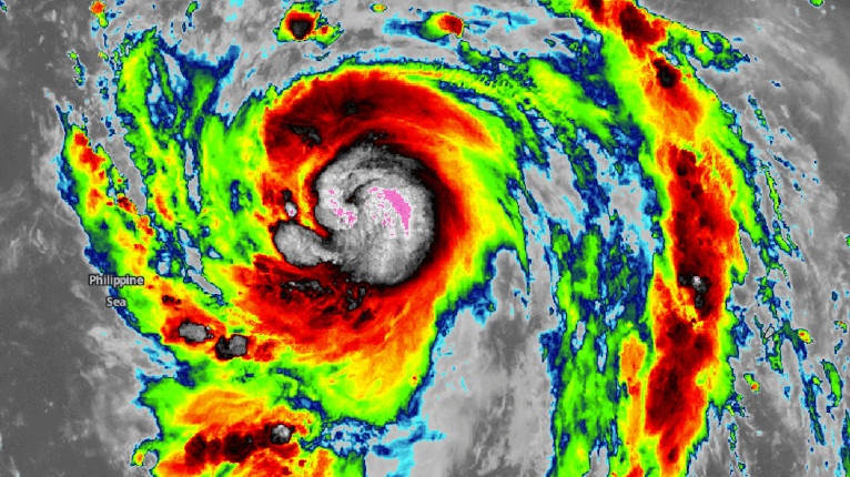
The Pagasa senior weather specialist reported that outside PAR (Philippines Area Responsibility) particularly in the eastern part, they are monitoring a typhoon with the international name Haishen. The hurricane of category 2 could hit the Filipino territories tomorrow already.
Philippines: what is the power of Typhoon Haishen and where the hurricane will land?
“Haishen” has maximum sustained winds of 130 kilometers per hour (kph) and gustiness of 150 kph. It is moving west-northwest at 20 kph. Once it enters PAR, the typhoon will be locally named as “Kristine.”
Meanwhile, Dela Cruz said the southwest hurricane will bring moderate to strong winds in northern Luzon. Pagasa’s forecast showed that the entire country will have partly cloudy to cloudy skies with isolated rain showers due to the southwest monsoon or localized thunderstorms.
The Pagasa advisory sheet reports that hurricane Haishen continues to intensify as it moves towards the Philippines and that the typhoon “eye” estimated based on all available data at 1,695 km East of Extreme Northern Luzon (OUTSIDE PAR)(20.2°N,138.2°E)
FOR MORE INFORMATION ON SAFETY AND FORECASTS: PAGASA official website
How to survive a hurricane or a natural disaster? You must have an emergency kit bag.
WATCH BELOW HOW TO PREPARE IT!
Typhoon Haishen – SOURCE